Disclosure: Some links may be affiliate links. This means that I may earn a small commission if you decide to buy (at no additional cost to you)
Last Updated on September 2, 2026 by Erin Donahue
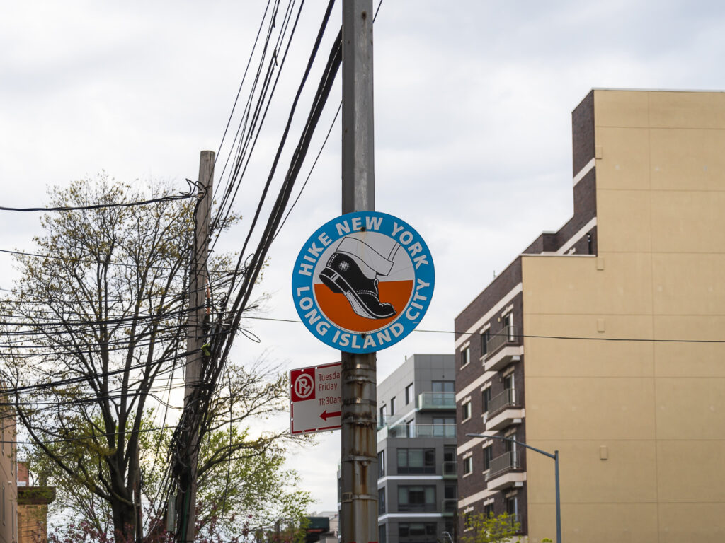
You may have noticed these quirky signs scattered throughout Queens without ever looking into what they were for. I know I did. Then, during COVID lockdown, I had nothing better to do than walk around Astoria — I lived there at the time (oh, how I miss it!) I kept spotting them everywhere, and finally decided to figure out what they were all about.
As someone who’s been in New York City for almost 15 years, one of my favorite things about The Big Apple is how walkable it is. Nothing beats the convenience! The city has quite a few hidden gems without leaving the five boroughs if you know where to look. Included in this is a five-mile loop through Queens called “Hike New York – Long Island City” that’s marked with signs. Previously, I shared my experience walking 32 miles around the perimeter of Manhattan in a DAY, but this one’s a much easier way to spend an afternoon.
Hike New York – Long Island City Quick Facts
- Distance: ~5 miles
- Neighborhoods: Long Island City, Astoria, Sunnyside (Queens)
- Created: June 1994, by artist Richard Deon with the Public Art Fund
- Markers: Orange-and-blue street signs featuring a cuffed trouser leg and dress shoe mid-stride
- Cost: Free, self-guided
- Original sign count: 44 pairs (many have since disappeared)
Part Art Exhibition, Part Hiking Trail

Created in 1994 as an art installation by Richard Deon in partnership with the Public Art Fund, this 5-mile route goes through Long Island City, Astoria, and Sunnyside. As someone born in the early ’90s, it’s crazy to think this exhibition has been around almost as long as I have. What makes it delightfully quirky is that a series of street signs mark it, depicting a logo of a cuffed trouser leg and black dress shoe in mid-stride.
According to Deon, the idea behind using a dress shoe design was to attract metropolitan “hikers” since NYC is such a walkable city. Originally, there were 44 pairs of these orange and blue signs stationed along major roads, such as Jackson Avenue and Vernon Boulevard. This path curates an urban hiking experience by blending outdoor trails with a tour of LIC’s diversity and transformation. You’ll meander through Long Island City’s once-gritty industrial areas, past transportation hubs and electrical infrastructure, before passing cultural landmarks like Kaufman Studios — the original “America’s Hollywood” in Astoria during the 1920s and ’30s. Along the way, you’ll catch skyline views of Manhattan across the East River.
Pieces of New York City History
Part of the fun is feeling like you’re on a scavenger hunt. Many of these trail signs have disappeared over the years. I assume that it’s most likely because people stole them for souvenirs. Or perhaps they were discarded during changes and renovations in their neighborhood. Additionally, a few of the original points have changed since 1994 — some institutions have closed, and others have been renamed. I guess the ever-evolving nature of this hike is the legacy of it. You’re glimpsing the past and present of this part of Queens. With Long Island City in particular changing as fast as it is, these signs are worth preserving. They’re one of the few things left pointing back to what this neighborhood used to be.
Whether you’re a born-and-bred New Yorker or visiting from out of town, I recommend walking along this “Hike New York – Long Island City” trail. It offers the perfect way to explore the Queens shoreline while stumbling upon cultural attractions, architectural gems, and local spots. The next time you find yourself in LIC, Astoria, or Sunnyside, keep your eyes peeled for those quirky dress shoe trail markers. You just might discover a whole new side of NYC you never knew existed!
Map of Hike New York – Long Island City Signs
I mapped every location of the Hike New York – Long Island City sign I could track down myself. However, many have vanished over the years, so this list is periodically updated. Know of one I missed? Drop it in the comments!
Get the full map when you subscribe below.
Hike New York – Long Island City FAQ
How many miles is the Hike New York – Long Island City trail?
The trail runs about 5 miles through Long Island City, Astoria, and Sunnyside.
Are the Hike New York signs still up?
Some are. The original 44 pairs have thinned out over the years. Souvenir hunters may have taken a few, so part of the fun is spotting the ones that remain.
Is the Hike New York – Long Island City trail free?
Yes. It’s a self-guided walking route — just follow the street signs.
Is Long Island City the same as Long Island?
No. Long Island City is a neighborhood in Queens, one of NYC’s five boroughs. Long Island is the much larger landmass to the east. This trail only covers the small LIC/Astoria/Sunnyside stretch, not the island as a whole.

Comments +